
Uncategorized
Winnipeg Trails Bingo
HOW IT WORKS: Print or save this on your phone. Grab your dauber, er.. bicycle.. and ride, don’t hide, and go seek! Winnipeg Trails Bingo is
HOW IT WORKS: Print or save this on your phone. Grab your dauber, er.. bicycle.. and ride, don’t hide, and go seek! Winnipeg Trails Bingo is
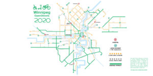
What do you do when up to 168,000 passenger daily transit trips suddenly need to be repurposed? Where do kids and families go to get
With COVID-19 affecting many aspects of our lives but especially public transit, many people are scrambling to find healthy ways of getting to work, run
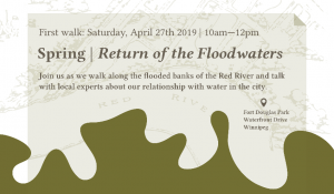
Learning from the Land, in the City is a new series of four seasonal walking tours organized by Urban Ecology Winnipeg. It explores the connection

RESULTS of Beautiful, Safe and Connected: 20 Question Candidate Survey on Human Transportation On October 16, Winnipeg Trails staff and board prepared and sent a
The Winnipeg Trails Association is pleased to announce our first ever 2018 Annual General Meeting (although we were founded in 2003, we existed as a
The Winnipeg Trails Association is pleased to announce the 2018 Annual General Meeting will be held on September 27th at The Forks Market starting at
Join us on September 27th from 3:30-5:30pm for a pre-AGM Community Trail Count. A Community Trail Count is a simple way for citizens to measure
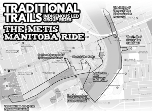
Traditional Trails Manitoba Métis Ride Sunday August 12. Join Adrian Alphonso and Jenna Vandal for a fascinating and invigorating trip through the history of this

Contribute to the Vibrancy of Your Community Trail Committee Members and Chair Needed The River East Neighbourhood Network – Trail Committee (RENN-TC) is a sub-committee