Trail Stewardship Group: Transcona Trails Association
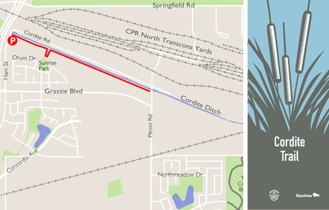
The Cordite Trail is situated in a very open meadow-like field area and runs along the south bank of the Cordite Ditch at the northern edge of Transcona. The western section which begins at Lagimodiere Blvd is north of Kildonan Estates and the east section crosses Redonda in East Transcona. Currently there is a gap in the trail between Plessis Rd and Day Street.
The Cordite Trail is named after the Cordite Plant that was built in Transcona because of close proximity to water, fuel, power, labour and rail lines. Between 1941 and 1945, the plant manufactured cordite, an explosive material used in munitions along with nitrocellulose and nitro-glycerine, also used in explosives. When the Second World War ended, the plant was used as Japanese Interment camp for a few months.
Eventually the site was cleared and today this peaceful area provides an ideal environment for marsh birds, hawks and other wildlife. The bulrushes provide shelter for nesting geese and ducks in the spring, and often you can see foxes sneaking around! The trail is popular with area residents for walking, cycling, dog walking, and children’s play.
FAST FACTS
- grass surface
- 1.8 km & 1.1 km route lengths
- Parking
On neighbourhood residential streets
Harold Hatcher School, 500 Redonda Street
Hamm Street
POINTS OF INTEREST
- Transcona Community Bioreserve – This former site of an industrial plant has been turned into a naturalized park with over 1.6 km of crushed limestone
trails. - Transcona Trail – This grass path follows a Manitoba Hydro right of way and is used by walkers, runners and cyclists.

