

Trail Stewardship Group: Naturalist Services Branch
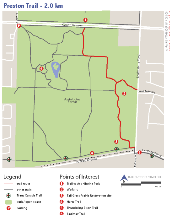
The Preston Trail is located within Assiniboine Forest, Canada’s largest 280 hectare urban nature park. This new granular trail is very popular with walkers, cyclists and joggers. Many bark chip trails extend from the Preston Trail enabling further exploration of the forest. Along the north portion, the Preston Trail winds through aspen and oak habitat, where smaller numbers of Balsam Poplar are also present. Midway along the trail, an observation mound provides great views of a recently constructed wetland, while the mound itself contains examples of native tall grass prairie plant species. At the south end of the trail, visitors will encounter an 3 hectare section of restored tall grass prairie. Named after the Preston family that once resided where Assiniboine Forest is now, the trail has been designed to minimize ecological impacts, while providing an interesting and scenic route through this natural heritage area.
FAST FACTS
- crushed limestone surface
- 2.0 km route length
- Parking
Assiniboine Forest main entrance parking lot on Grant Avenue at Chalfont Rd.
POINTS OF INTEREST
- Trail to Assiniboine Park – This asphalt pathway continues on to Assiniboine Park, Assiniboine Zoo and other area features.
- Wetland – The new wetland was constructed in 2005 as part of a drainage and wetland enhancement project to alleviate drainage challenges in Assiniboine Forest
- Tall Grass Prairie Restoration site – Formerly a landfill, this 3 hectare site was restored to tall grass prairie in 2004. The mound on the site provides a scenic view of the area.
- Harte Trail – Built on a unused rail bed, the 6.5 km Harte Trail is part of the Trans Canada Trail system.
- Thundering Bison Trail – provides a key link to FortWhyte Alive nature centre.
- Sagimay Trail – This trail leads into Assiniboine Forest from the main entrance parking lot.